The Turnpike Road
Whilst it soon became obvious something needed to be done for maintenance of the roads is an expensive business and money needed to be raised. Parliament passed Acts to force provision for the repair of the highways and the Toll or Turnpike Road came into being.
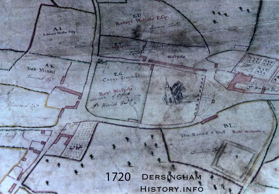
Attleborough to Wymondham 1695 was the first such road here in Norfolk followed by Norwich to Scole in 1708. Then in 1768 an Act of Parliament was passed for “widening the roads from the East gate to Gayton, Grimston and to the North end of Babingley Lane”. The Act directed that the road should run, “from the said Wootton Gaps, through the parish of Castle Rising to the South End of a certain other bridge called Babingley Bridge in Babingley and from the North End of the same bridge to the North End of Babingley Lane in Babingley.”
Toll gates were to be erected and among the Trustees were names familiar to Dersingham villagers; William Hoste, Henry Cornish Henley (Sandringham) Theodore Hoste, Dixon Hoste and William Hudson. The Hostes were large landowners in the area. Life Wood in Dersingham was known for many years as Mr. Hoste’s Plantation.
On April 4th 1811 in the reign of King George the following Act was presented to Parliament. An Act to enlarge the term and powers of the two acts of His Present Majesty for repairing the road from the East Gate of King’s Lynn to the North End of Babingley Lane and to extend the road from thence to Darsingham in the County of Norfolk. The following is an extract taken from this Act:
Whereas the road leading from the North End of Babingley Lane through the parishes of Babingley, Wolferton, and Sandringham to the sign of The Dun Cow in Darsingham is much out of repair, incommodious and dangerous for travellers and cannot be effectually amended and kept in repair by ordinary court of law. It would be a great accommodation to the neighbourhood and of public utility if the same were to be repaired and put under the care and management of the Trustees for executing the said Act. May it therefore please your Majesty that it may be enacted.
It continues to make a plea for an act to be put in place for the purpose of Amending, widening, improving and keeping in repair the road through the parishes of Babingley, Wolferton, and Sandringham to the sign of the Dun Cow in Darsingham.
The next section was of great importance and would have been welcomed by all here in our village and no doubt secured the cooperation of everyone.
No turnpike or Tollgate shall be erected or set up, or toll collected by virtue of the said acts upon any part of the said road leading from the North End of Babingley Lane to the sign of The Dun Cow in Darsingham.
It was also recorded that £950 had been subscribed for paying the expenses of making the intended road.
In the Act of 1768 a list of tolls charged is recorded.
Every horse, mare, gelding, mule or other beast laden or unladen, and not drawing the sum of one penny halfpenny.
For every chaise and one horse, the sum of four pence halfpenny
For every coach, machine, Landau, Berlin, Chariot, Chaise, and two horses the sum of nine pence
For every such carriage and four horses the sum of one shilling and sixpence
For every such carriage and six horses the sum of two shillings.
For every cart or curry and one horse the sum of three pence
For every cart with not more than four horses the sum of nine pence.
For every cart with more than four horses the sum of one shilling
For every waggon having more than four horses and not more than six horses the sum of one shilling and sixpence.
For every waggon having more than six horses the sum of two shillings.
For every drove of oxen, cows, or neat cattle the sum of one shilling and three pence per score and so in proportion for any greater or lesser number.
And for every drove of calves, hogs, sheep or lambs the sum of seven pence half pence per score and so in proportion for any greater or lesser number.
Waggon denoted a road vehicle. Wagon became the term used for a railway wagon.
This gives an interesting picture of the sort of traffic one would meet on early 19th century roads to and from Dersingham. The Directories of the time record cattle dealers and horse dealers being active in the village. Both sheep and cattle were grazed on the marshes so there would have been many occasions when the animals were moved to the markets in Lynn. So although according to the Act of 1811 no toll gates were to be erected on the road from Babingley to Dersingham once approaching and entering Lynn tolls would be collected.
There were certain safeguards and exemptions. For instance the Act states
No person passing through any of the said Turnpikes of gates who shall return or pass through the same Toll gate on the same day with the same horses, cattle, beasts, or carriages and who shall produce a note or ticket of the day denoting that the toll was paid in that day shall be liable to pay the said toll more than once in the same day at the same gate.
This would have been of great importance to the carriers in the village. There were also further exemptions
Beasts carrying materials for repairing roads
Carts with grass, hay or corn to be placed in outhouses on the land of owners
Carts with dung, compost, manure or lime for improving or manuring the land
Owners or their servants going to their lands to look after them
Animals going from one pasture to another
The horses of soldiers on the march
Carriages travelling with vagrants sent by legal passes, or returning having been employed.
Traffic on election business.
Even with all these exemption Toll Roads were extremely unpopular. Faden’s map of 1797 records 40 Toll gates in Norfolk. Tollgates are recorded in Gaywood and at Mintlyn. There were severe penalties for defacing or destroying Toll gates. A board had to be placed at the Toll House containing a list of all the charges.
In 1822 it was ordered that the names of Towns and Villages were to be put up at the entrance and milestones and direction posts were to be set up one mile apart denoting the distances to a town or place. The penalty for defacing them would not exceed ten shillings.
The route of the original road from Hunstanton to Lynn can still be observed by noting these old milestones some of which are still standing at the side of the road. They have recently been restored and painted white. The 8mile stone stands by our village sign as you enter from Lynn. It was often used by the Parish Council in the past to help identification if that area was being discussed. The 9mile stone can be seen as you leave the village on the right opposite Life Wood, and the 10mile stone is in Ingoldisthorpe. Unfortunately the 11mile stone on the left as you go up the hill in Snettisham towards the round-about is damaged which is probably why it was not highlighted like the others. The 6, 7, 13 ,15 and 16 mile stones can still be seen but the others have been lost probably when the new roads were constructed in more recent times.
In 1826 in an attempt to minimise damage to the road surface further regulations were put in place to standardise the construction of the wheels of vehicles. The breadth of wheels for the various wagons and coaches was strictly laid down and owners of carts, wagons, or coaches not complying were fined £5; the driver was fined 40 shillings.
No cart with wheels of less than 3 inches breadth was allowed to be used on the roads. The amount of weight any vehicle could carry was dependent on the breadth of the wheels which were measured at the Tollgate and at some weighing machines were installed to enforce the regulations. Additional tolls had to be paid for overweight and there were severe penalties for unloading a vehicle before the tollgate to avoid paying tolls. If Toll charges were not paid within 4 days then goods could be seized to that amount. (Some of this reminds me of airport travel.)
In King’s Lynn library there is a lengthy publication produced in 1836 which details the complaints of local landowners and farmers concerning the money raised from these roads and the unfairness of the system. Among the signatories are the names Richard Stanton and George Rix both well known land owners here in Dersingham.
The Golden Age of Coach Travel
The 18th and early 19th century heralded the golden age of coach travel. Stage coaches competed with the Mail coaches for passengers. The fares on stage coaches were cheaper but the vehicles were not as comfortable or as well protected as those of the Mail service. By1837 Norfolk’s main links were established to London via Ely, Downham Market, King’s Lynn and Hunstanton. From 1780 macadamised cambered roads had been introduced and provided a harder, drier surface to make travel easier. This with improved carriage designs meant that on these roads speeds of up to 10m.p.h. could now be achieved in most weather conditions. Non turnpike roads were often improved by local landowners to reap the benefits of enclosure and despatch their increased harvests to market.
In 1785 Lynn to Norwich was a seven hour trip. In 1842 the day coach from Lynn to Norwich took four and a half hours at a cost of 10s. for an inside seat and 5s. if you travelled outside.
So if we travelled from Dersingham to Lynn in the 18th/early 19th century we would probably have boarded our stage coach, or perhaps used the services of one of the local carriers, at the sign of The Dun Cow to travel along the Turnpike road past Rice’s Common on our left, with Badger Fen and Cranberry Pasture on our right and on through the Sandringham area. From our vantage point on the coach we would see on our right all the way over the marshes to The Wash. Leaving Sandringham we would pass the road to our left that would take us to the small village of West Newton. The Turnpike would take us through Babingley and then bear right to pass across the bridge over the Babingley River and so up the hill to Castle Rising. (This part of the road now is only open to cyclists and walkers). We would pass the church on our right, the almshouses and then the old castle ruins on the left before continuing through the open countryside with the small village of North Wootton away to our right. In a short distance we would arrive at the equally small sister village of South Wootton and pass on our left the road that would take us to up a long hill and on to Grimston and Hillington. Today of course this is a busy crossroads controlled by traffic lights but then there was no road to the right and as we travelled on towards the village of Gaywood we would be going through open country with a clear view across the marshes on our right down to the River Great Ouse. Perhaps we could have seen the masts of all the ships entering the port of Lynn.
A short distance further on we would cross a bridge over the Gaywood River, close to the present day Marsh Lane, and just before we entered Gaywood where the road from Gayton came in on the left we would have stopped at the Toll gate and the fees would be paid. Then, passing the old Bishop’s Palace, still standing on the right and following the Gaywood River through open country we would finally enter King’s Lynn through the East Gate.
But just how would we have travelled? There were numerous options. From the trade directories of the time we can find
FROM HEACHAM
To LYNN REGIS John Mason and Ann Roberson, daily
FROM SNETTISHAM
To LYNN REGIS James Twiss’ cart and a sociable every morning (Sunday excepted) at six
A sociable, short for sociable coach, was an open 4 wheeled carriage which had two double seats facing each other and could be controlled from the interior by the owner-driver or have a box for a coachman. A pair of folding hoods protected the passengers and it could be drawn by a single horse or matching pair.
The cart was a two wheeled wagon drawn by one horse and was a general purpose trade or farm vehicle with no suspension.
More about the coach and cart operators can be found in our Businesses section.
The Mail Coaches
In the seventeenth century a public Mail service was set up by Royal proclamation and Thomas Witherings a London merchant was given the task of organising regular services to run day and night along the great postal roads. The improvement in the roads in the 18/19th centuries heralded the era of the stage coach as discussed above. In the 1830s letters could be delivered the morning after posting in towns more than 120 miles from London.
Mail coaches were four-wheeled covered vehicles drawn by teams of four in seven to ten mile stages. They were painted scarlet, maroon and black; the guards wore scarlet uniforms and carried blunderbusses, pistols and a horn. They must have been quite a sight on the road.
They competed with private stage coaches for the booming passenger traffic.
More about the Mail Coaches can be found in our Businesses section
The Carriers
Carriers were the traditional life line for small villages. Their carts, vans, and waggons provided a passenger and delivery service that was essential to small rural communities. They used vehicles similar to farm waggons but not usually as robust and they would be fitted with a canvas awning.
The waggon was a 4 wheeled heavy farm vehicle usually made by the local wheelwright. The carter walked alongside and controlled his horse by voice or a long whip. It had no suspension and large wheels. They would travel at about 3-4 m.p.h. and nearly all towns and villages advertised their services.
The village carrier would transport goods and passengers for a small fee to and from King's Lynn and other nearby villages. The Norwich Directory of 1783 lists Creaf and Teal's waggon leaving Norwich for Lynn each Thursday and returning on Friday at 10a.m. It would arrange for parcels to be carried on to Snettisham by local carrier and no doubt would stop in Dersingham if needed.
More about the coach and cart operators can be found in our Businesses section.
So we come to the end of the 19th century.
The road through Dersingham to Lynn must have been extremely busy especially on market days. Waggons, gigs, vans, sociables, carts, stage coaches and mail carts were constantly plying back and forth. Carriers from our village as well as those passing through from Snettisham, Heacham and Hunstanton would have been a familiar sight. There would have been constant traffic from the many farms here especially at harvest times.
A most popular form of travel for many of the villagers was the donkey and cart. During discussions on how the village was to celebrate the coronation of 1911 it was suggested donkey cart races would be a good idea as so many villagers had them.
I have found a reference to a very interesting character born here in the village in 1873. She was Elizabeth English who became known as “the cockle woman”. At the age of 9 she began to work for her father Hoddy Middleton and by 14 had her own donkey and cart. She would drive each morning down to the beach to gather cockles and samphire which she would then sell throughout the district.
The following is a transcription of a report found in The Lynn Advertiser dated 12 July 1879. This case heard at the County Court in Lynn gives a wonderful picture of the busy life on the roads of our village as well as a valiant attempt by the reporter to catch the flavour of the local accent.
LYNN COUNTY COURT
JOHN BUNN v. FRANCIS RINGWOOD
Plaintiff is a labourer at Dersingham, and defendant a teamman in the employ of Mr. Johnson, Heacham. Claim for £2/10 for a donkey killed through the negligence of the defendant driving a horse and wagon.
Mrs. Ann Langley said she was driving three donkeys along the lane past The Dun Cow. She saw the defendant coming along the road, and cautioned him not to run over her or the donkeys. No sooner had she spoken to him than he ran over Mr. Bunn’s donkey, and hurt it so that it died a few hours after.
Mr. Wilkin, who appeared for the defendant, asked the witness how old she was, to which the witness objected to answer.
Mr. Wilkin: Well, if you won’t tell us how old you are, will you tell us how old the donkey was ?
Witness: I don’t know how old it was.
Mr. Wilkin: Well, it wasn’t quite so old as you. Was it 20 years old?
Witness: No, I should think not.
Mr. Wilkin: Well, I have given you the benefit of it. I put you down as sixty.
Witness said she was certain there were not nine or ten donkeys on the road.
Mrs. Mitchell deposed to seeing the accident. As well as the previous witness she admitted that the defendant was only going at walking pace.
Mr. Wilkin having opened his case, the defendant said that on the day in question he, with another teamman, was going from Lynn to Heacham, and when they got to the Dun Cow at Dersingham, they overtook a lot of donkeys, some six or seven at least, driven by Mrs. Langley. The donkeys kept “pottering” and “messing” about between the two teams, and in and out of the horses. He sung out to the woman,
“If yow don’t kape them dickies out o’ my way, yow’ll git one on ‘em killed.”
He was only walking his horses, and did not see the donkey till it was knocked down.
John Smith, the other teamman with the defendant, gave corroborative evidence. He said that every care was exercised by himself and Ringwood to avoid doing an injury to the donkeys.
His Honour, in giving judgement for the defendant, said it was rather a hard case.
Mr. Wilkin said hard cases make bad law; but he would write to Mr. Johnson, who would no doubt give Mr. Bunn a sovereign.
A vivid picture is easily imagined of the two wagon teams with the drivers walking alongside making what was probably a regular journey between Lynn and Heacham for them and countless others. Meeting donkeys or indeed cows or sheep. being herded through the village was probably not an unusual hazard at that time.
Donkeys were frequently a cause for complaint as shown in one Parish election. One of the candidates made known that .
”If you vote for me I will see to it that donkeys are kept off your gardens”. I have not discovered if he was duly elected.
The care of all the many wagons and carts in the village, especially in the winter months when the roads and lanes were often muddy, was also not without its problems. In the notes from the parish Council in 1895 there were numerous complaints received concerning the washing of carts on the recreation ground and the nuisance caused by the resulting mess left behind causing the drains to become blocked.
We must also remember that cattle and sheep were herded through the village from the high pastures down to the marshes for summer grazing and at other times to Lynn market by drovers although they did avoid the main roads where possible and use drift and drove tracks if they existed.
Then there would also have been all the private carriages, the phaeton, barouche from the more wealthy families in the district. Tradition states that the last owner of Snaring Hall here in Dersingham drove about the village in a coach drawn by four black horses.
Elizabeth Postlethwaite,in her letters to her sister, who was married to Samuel Kerrich the vicar here 1729 - 1768, frequently expresses the hope that her sister will visit in the chariot. A chariot was a stately four-wheeled carriage with back seats only. The travelling chariot was considered to be the private vehicle of the nobility. Elizabeth writes often of the chariot to London.
It was in 1835 that Parliament passed the Act to make driving on the left a lawful requirement. One can only imagine the chaos on busy days when everyone decided for themselves their position on the road.
In 1861 more action was needed so Parliament passed The Offences against the Person Act to deal with the reckless handling of horses. Those arrested were accused of "wanton and furious driving." It illustrates our continued links to the past when last year, 2017, this Act, still on the statute books, had to be used to prosecute a cyclist in London who had caused the death of a pedestrian by reckless "driving". There was no modern equivalent relevant to a cyclist under which he could be charged. Needless to say Parliament is looking at changes to the law to better reflect modern times.
Many trades and businesses were essential to maintain the smooth running of all this traffic. The horse was King so every village had its skilled blacksmiths, wheelwrights, saddlers and harness makers. Robert, John and James Frost were blacksmiths here from 1836 to at least 1874. William Potter was one of the blacksmiths here who built his smithy,(still standing), on the corner of Post Office Road and Centre Vale and was an essential part of our village for many years. The Flegg family were wheelwrights and there were the saddlers and harness makers who were all essential parts of village life.
The End of an Era
From the middle of the 19th century an ominous puff of smoke could be spied on the horizon. That great marvel of the time, the locomotive, was announcing its arrival.
By 1845 King's Lynn had joined the "railway mania" and in 1848 was linked to London by rail. Other lines soon followed and the rail network spread throughout the county and beyond. In 1862 the line from Lynn to Hunstanton was built and Dersingham Station became an extremely important part of the village. The track that used to wind down to the windmill, as stated earlier, became Station Road with The Alexandra Public House and Hotel, Station cottages, the Station master's House and the station with its cattle and loading yards beginning the process of stretching the village to the west of the Main Road.
Local businesses like Enoch Taylor at the newly built Feathers Hotel began advertising that they had conveyances to meet every train arriving at Wolferton and Dersingham. Waggonettes were available for trips to Sandringham.
The golden age of coach travel was over. In his New Year message of 1900 to welcome the new century to come Edward Penney, the vicar, remarked, "Shall we live to see the locomotive rusting on the scrap heap as some of us may remember to have seen the old stage coach rotting in the wheelwright's yard?
However in the late 19th century another form of transport began to appear on our roads. In the 1890s we enter ....
The Golden Age of the Bicycle
The bicycle was developed from the "dandy horse" the first human means of transport to use only two wheels. The history of the development of the bicycle whilst most interesting does not have a place here. It needs only be said that by the 1890s development had been rapid and many innovations, such as the pneumatic tyre, increased the comfort and ease of riding the new bicycle. The "safety bicycle" had arrived.
The Raleigh Bicycle company was founded in England in 1888 and others soon followed. The "rover" manufactured in Coventry in 1885 was the first recognised modern bicycle.
Cycling clubs were formed all over the country so that the bicycle joined the horse carts and donkey carts to become the mainstays of transport before the automobile arrived.
For women the bicycle was designed with the step-through frame which would allow them to mount and dismount in a dignified way while wearing the long skirts of the time. It was considered most unladylike for a woman to open her legs to mount or dismount. This cycling craze led to the movement for rational dress and had the effect of liberating women from the corset and ankle length skirts. They began to wear the "bloomers" that quite scandalised many in society. Some considered this was all part of the emancipation of women which would lead on to the suffragette movement.
Road travel had always been very expensive and holidays and day trips were only taken by the more wealthy of the village. The railway, especially with the "parliamentary fares," had already put day trips within the reach of all villagers. Trips to Hunstanton, Lynn and even further afield were now regularly enjoyed. The development of the bicycle now also allowed the ordinary villager to travel for leisure into the country and reduced the dependence on the horse. The bicycle began to be used not only for leisure but also in businesses for messengers, mail carriers and delivery boys. This all brought the need for maintenance and repair.
Evidence that the bicycle age had reached Dersingham can be found in the 1896 Directory. There for the first time John Henry Chambers of Dersingham is recorded as Agent for the Coventry, Quinton, Globe and other cycles. As the century closes and the new one begins we find in 1900 not only John Henry but also Albert Jackson, Cycle repairer.